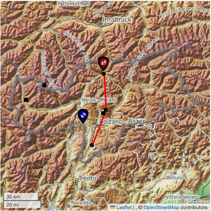
Alpine-Crest Target Area
Target Area reprensentative: Charles Chemel (National Centre for Atmospheric Science).
Last updated: 6 November 2024
Permanent operational infrastructure
Weather station networks
Weather stations in the ACTA are operated by several organisations in the regions overlapping Austria and Italy, including:
- in the region overlapping Austria: the Austrian national weather service, known as GeoSphere Austria, and the avalanche warning and hydrological services of the state of Tyrol;
- in the region overlapping Italy: the meteorological and avalanche warning services of the Autonomous Provinces of South Tyrol and Trento.
Weather radar
There is one operational weather radar in the ACTA: the dual-polarisation Doppler C-band radar at Monte Macaion, operated by the Autonomous Province of Trento in partnership with the Autonomous Province of South Tyrol.
Eddy covariance station networks
The ACTA encompasses three eddy covariance stations: one from the Integrated Carbon Observation System (ICOS) network, located at Renon, and two operated by the University of Innsbruck, located at Hintereisferner and Muntatschinig.
TEAMx Observational campaign (TOC)
TOC backbone infrastructure
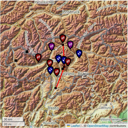
The principal goal of the TOC backbone infrastructure is to monitor the vertical structure of the mountain boundary layer across the TOC domain, primarily during the winter and summer EOPs. The surface-based remote sensing and radiosonde launch sites making the TOC backbone infrastructure in the ACTA are indicated in Figure 1. In addition, a transect of about 8 to 10 microbarographs will be deployed across the TOC domain. Three of these microbarographs will be located in the ACTA (see Figure 1). As the planning for the TOC progresses, site locations may change slightly, and additional sites may be added.


Figure 1: Surface-based remote sensing and radiosonde launch sites making the TOC backbone infrastructure in the ACTA.
Winter EOP
The focus of the winter EOP will be on the IVTA and the TOC deployment in the ACTA will be limited to that of the NCAS supersite at Sterzing, including regular radiosonde launches, and the weather radar deployed by KIT at Rittner Horn.
Summer EOP
The summer EOP will integrate activities across the TOC domain. The ACTA will be central and host a network of surface based remote-sensing instrumentation (NCAS supersite at Sterzing, NCAS weather radar site at Plose, a network of sites operated by KIT, and multiple sites operated by the Universities of Cologne and Vienna). In addition, airborne observations using the FAAM BAE-146 aircraft and TU Braunschweig Cessna are planned.
Ground-based observations
NCAS supersite at Sterzing (winter EOP to end of summer EOP)
The site will provide continuous near-surface fluxes and boundary-layer winds, temperature, humidity, aerosol layering and cloud base. Radiosondes will be launched during the EOPs, 3-hourly during the IOP days and twice daily during the non-IOP days. [Contact: Phil Rosenberg, UK NCAS]NCAS transect of (up to 8-10) microbarographs (winter EOP? to end of summer EOP)
These sites will provide air pressure to infer orographic drag along the Alpine transect. The microbarographs will be deployed at existing sites, either operational Automated Weather Station sites or operated by TEAMx project partners. [Contact: Phil Rosenberg, UK NCAS]NCAS weather radar site at Plose (summer EOP)
This site will provide areal precipitation, radial velocity, and properties of hydrometeors. The combination of multiple radars, when possible, will also allow multiple Doppler retrieval of winds over the Sarntal Alps region. [Contact: Lindsay Bennett, UK NCAS]KIT network of sites (summer EOP)
These sites will provide continuous near-surface fluxes and boundary-layer winds, temperature, humidity, aerosol layering and cloud base. Radiosondes will be launched at the KITcube main site during the summer EOP, 3-hourly during the IOP days and twice daily during the non-IOP days. The sites include: Bozen airport (KITcube main site): near-surface fluxes and boundary-layer winds, temperature, humidity, aerosol layering and cloud base; Gargazon, Naturns, St. Martin in Passeier, Sarnthein, Kollman: boundary-layer winds, humidity, aerosol layering and cloud base; Mezzaselva/ Sachsenklemme: boundary-layer winds. [Contact: Andreas Wieser, KIT]KIT network of Parsivel disdrometers (summer EOP)
These sites will provide size and fall velocity of hydrometeors. The Parsivel disdrometers will be deployed at existing sites, either operational Automated Weather Station sites or operated by TEAMx project partners. [Contact: Jan Handwerker, KIT]KIT weather radar site at Rittner Horn (from the beginning of the TOC to the end of the summer EOP):
This site will provide areal precipitation, radial velocity, and properties of hydrometeors. The combination of multiple radars, when possible, will also allow multiple Doppler retrieval of winds over the Sarntal Alps region. The site will also have a surface energy balance station. [Contact: Jan Handwerker, KIT]KIT weather radar site at Bozen (summer EOP)
This site will provide areal precipitation, radial velocity, and properties of hydrometeors. The combination of multiple radars, when possible, will also allow multiple Doppler retrieval of winds over the Sarntal Alps region. [Contact: Jan Handwerker, KIT]University of Cologne/KIT sites at Rittner Horn (summer EOP)
The site at Rittner Horn, operated by KIT, will be complemented by two microwave radiometers, two micro rain radars, and two Parsivel disdrometers, one of each at the mountain top and one of each at the base of the cable car leading to the mountain top. [Contact: Claudia Acquistapace, UoC]University of Vienna instrumented cable car (summer EOP)
The cable leading to Piffinger Köpfl from Meran will be instrumented with temperature, humidity and wind sensors. It is also planned to deploy a network of 5 to 10 weather stations in region of Meran. [Contact: Manfred Dorninger, UoV]Airborne observations
FAAM BAE-146 aircraft (summer EOP)
Aircraft flights are planned with the FAAM BAE-146 aircraft to characterise the dynamics of ridge-scale thermals and waves. [Contact: Doug Anderson, UK NCAS]TU Braunschweig Cessna (summer EOP)
Aircraft flights are planned with the TU Braunschweig Cessna to characterise the controls of valley flows on vertical exchange in the Sarntal Alps region. [Contact: Philipp Gasch, KIT]Modelling Activities
Model evaluation/development
The focus will be on boundary-layer turbulence, orographic convection and orographic gravity waves.
FUNDED PROJECTS
TEAMxUK: Quantifying atmospheric processes in mountainous regions
This NERC-funded programme seeks to improve the understanding and model representations of orographic processes across scales for:
- weather and climate prediction
- the UK’s management of vulnerability, risk, and resilience to associated environmental hazards and change.
TEAMxUK is an integrated composite programme, which consists of two major coordinated elements: (1) a field deployment as an integral part of the wider TEAMx Observational Campaign in the European Alps, which will enable the construction of a unique dataset for quantifying atmospheric processes in mountainous regions; (2) four component projects (TEAMx-FLOW, TECTTO, TEAMx - Orographic convection, and OFRAM) that will exploit this dataset to develop and evaluate scale-aware parameterisations for weather and climate models.
TEAMx-FLOW: Flow Dynamics, Scale Interactions and Mountain Waves for TEAMx-UK
It focuses on the representation of orographic drag (parameterised and resolved) in the Unified Model and Momentum. [PIs: Andrew Orr, British Antarctic Survey; Corwin Wright, Neil Hindley, University of Bath; Andrew Ross, University of Leeds]
TECTTO
The Turbulence Evaluation in Complex Terrain using TEAMx Observations (TECTTO) focuses on the representation of boundary-layer turbulence (parameterised and resolved) in the Unified Model and Momentum. [PIs: Helen Dacre, Natalie Harvey, University of Reading; Ian Renfrew, University of East Anglia]
TEAMx - Orographic convection
It focuses on the representation of orographic convection (parameterised and resolved) in the Unified Model and Momentum. [PIs: Andrew Ross, University of Leeds; Andrew Orr, British Antarctic Survey]
OFRAM
The Orographic Flow Representation in the Alps at Multiple (OFRAM) scales focuses on the representation of turbulent mixing in orographic flows across multiple scales (parameterised and resolved) in the Unified Model and Momentum. [PIs: Ian Renfrew, Daniel Smith, University of East Anglia; Helen Dacre, University of Reading]
